Overview
Embark Richmond Highway is an initiative to provide multimodal transportation solutions and create opportunities for economic development in the Richmond Highway Corridor. Multimodal means a transportation system that is inviting for pedestrians, bicyclists, transit users, and drivers.
County and state agencies, guided by an appointed Advisory Group and the greater Lee and Mount Vernon district communities, are analyzing and carrying forward recommendations from the Route 1 Multimodal Alternatives Analysis. The study was conducted by the Virginia Department of Rail and Public Transportation (DRPT), a state agency that oversees transit funding and planning. The Fairfax County Board of Supervisors approved of the Embark Richmond Highway plan on Tuesday, March 20, 2018.
The approximately 10.4 mile corridor stretches from North Kings Highway at Huntington Avenue/Telegraph Road to the Fairfax County Parkway near Fort Belvoir. In addition to the roadways, the study area includes the land located within a ½ mile buffer of North Kings Highway and Richmond Highway.
The Embark Richmond Highway Plan Amendment responds to recommendations from the Route 1 Multimodal Alternatives Analysis and refines the recommendations from the study to provide more detailed guidance in the Comprehensive Plan for the implementation of transit in the corridor.
Embark Richmond Highway (Plan Amendment 2015-IV-MV1) is an initiative focused on creating a multimodal future for Richmond Highway Corridor where residents, workers, and visitors can walk, bike, or drive to the places they want to go.
This effort responds to recommendations from the Route 1 Multimodal Alternatives Analysis, conducted by the Virginia Department of Rail and Public Transportation (DRPT) and intends to assess and refine the recommendations from the study by providing more detailed guidance in the Comprehensive Plan for the implementation of transit in the corridor. Embark Richmond Highway also includes coordination with the Virginia Department of Transportation (VDOT) and federal agencies to conduct Environmental Assessments (EAs).
Comprehensive Plan Amendment:
The Comprehensive Plan Amendment process is:
- Planning goals and objectives for the corridor.
- Land use density and mix for the areas in the vicinity of the proposed BRT stations between Huntington and Fort Belvoir.
- Corridor-wide transportation systems, urban design, public facilities
ROAD WIDENING:
Richmond Highway is planned to be widened from four to six lanes
- The Virginia Department of Transportation (VDOT) is at the beginning of right of way acquisition for the Richmond Highway Corridor Improvements project, which will widen Richmond Highway from Jeff Todd Way to Sherwood Hall Lane (Route 626). Please refer to the VDOT project website for more information
BRT SYSTEM:
The goal of the BRT system is to increase transit ridership along the Richmond Highway Corridor and ultimately lead to the future Metrorail extension to Hybla Valley. Right of way acquisition for the BRT is scheduled to begin in FY20, with construction scheduled to begin in FY23. A document prepared by the Northern Virginia Transportation Authority has details on the first two phases of the bus rapid transit system, see the second bullet point below.
- The 3rd Public Information Meeting was held on September 17, 2019. The survey closed on November 1, but you can submit any additional comments here.
- Richmond Highway Bus Rapid Transit Phases 1 & 2. To learn more, click here.
Media:
-
Covering the Corridor, 6/4/2018: NVTA staff recommends full funding for Route 1 projects; final vote next week
-
Fairfax Times, 3/30/2018: Fairfax County approves Richmond Highway plan
-
Washington Business Journal, 3/21/2018: Fairfax County signs off on massive Richmond Highway overhaul
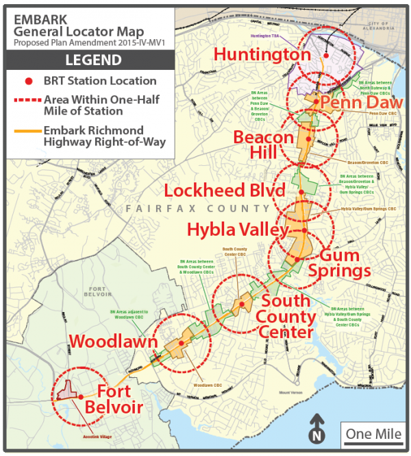
EMBARK Richmond Highway Map
Each red dot is a proposed BRT (Bus Rapid Transit) Station.
“These are big projects and they will take several years to accomplish, and they are currently in the beginning stages. $10 million in federal and regional funding has been dedicated to begin the Environmental Assessment (EA) and land use planning processes.
Because these steps are expected to take four years to complete for the BRT portion, the widening project will proceed ahead. The goal is for the widening to be accomplished by 2020 and BRT by 2026.
Several members of the SFDC Board of Directors joined other Lee and Mount Vernon District appointees on an Advisory Group to assist the county staff during the land use planning process.
Yes, it’s a long, drawn-out affair. But we hope you will stay engaged and participate whenever the county reaches out to the community for feedback.”
– SFDC Executive Director

